Mining at Fire Mountain
Walker Valley’s unique geology has attracted mining prospectors since European settlement of the area began in the 1880s. Early prospectors found coal seams along the sides of the Cultus Mountains and made small shafts. Later, lumber companies building railroad grades through the area struck coal seams, which led to the establishment of the Blumont Coal Mine on property adjacent to the entrance of Fire Mountain. Although large-scale mining never took place in the Walker Valley, the legacy of Fire Mountain’s mining days are evident to campers through the “prospect tunnel,” the “Miner’s Cabin,” and the Blumont Mine.
Prospect Tunnel
Located just below the water tower on the eastern edge of camp is an old mining shaft. The trail up to Cultus Mountain and Split Rock passes the shaft opening, which until 2001 was enclosed in a second-growth forest. This mining shaft is very likely the one referred to in Bulletin No. 29, Division of Geology, as the “old prospect tunnel” located in the southwest quarter of the northwest quarter of Section 10, Township 33 N., Range 5 E. This was a coal prospect done by the Pacific Coast Steamship Company in the late 1800s located adjacent to a section of the Day Lumber Company railroad grade (still obvious just below the existing trail).
Miner’s Cabin
Early visitors to the Walker Valley noted that coal was uncovered in many of the ravines in the hillsides south of the above-mentioned mining shaft and in the Cultus Mountains. Along the “Settler’s Trail” route up Cultus Mountain are the collapsed ruins of an old prospector’s shack referred to at camp as the “Miner’s Cabin.” This structure was still standing until 1986, though there is very little to look at today apart from collapsed timbers. A few hundred meters up the trail from the Miner’s Cabin are several old pans that may have been used in prospecting. Down the trail from the Miner’s Cabin is an old trestle bridge across the Nookachamps River.
Blumont Coal Mine
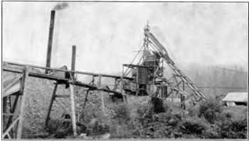
The Blumont Coal Mine was located at SW 1/4, SW 1/4, Sec. 33, T. 34 N, R. 5 E on the land of John B. Peterson. A coal vein was discovered here when the Day Lumber Company was constructing a railroad grade through the property in 1916. Later, the Sedro Wooley Coal Company began to sink an incline shaft on the coal outcrop. By the mid-1920s the mining shaft here was over 200 feet long and at a very steep angle. The complicated layout of the mine was necessitated because of the natural rock formations and faulting in the area.